|
| | NativeMapLayerViewModel (IGeoContext geoContext, IGeoNavigator geoNavigator, IMapLayerViewFactory mapLayerViewFactory, IMapResources mapResources, IElevationData elevationData, IMapController mapController, INativeTileCacheManager tileCacheManager, IMapServiceManager mapServiceManager, IMapInterfacer mapInterfacer, IColorInterpolationTableManager colorTableManager) |
| | Map layer view model that works with a native backend.
|
| |
| override void | HandleInputEvent (GeoInputEventArgs inputEventArgs) |
| | Called to forward events to the layer.- Parameters
-
If the layer handles the event, it must set the Handled property to true.
|
| |
| override void | Update () |
| | Event called at regular intervals to update contents of the layer.
|
| |
| override bool | IsDirty () |
| |
| void | PreExport () |
| | Called before actual export is performed. The layer must ensure that state that changes the appearance of the layer is not altered.
|
| |
| void | Export (Canvas canvas, IGeoContext geoContext, double targetDpi) |
| | The actual export function. Implementing classes should draw their content using the provided canvas and geo context.- Parameters
-
| canvas | The canvas to draw into. |
| geoContext | The geo context relevant for this export. |
| targetDpi | The wanted dpi for the export. |
|
| |
| void | PostExport () |
| | Called after export is performed. After this no more export functions will be called and the layer should go back to normal operation.
|
| |
| IRasterLayerData | GetAutoShadingLayer () |
| | Return raster layer for normal map shading (if any)
|
| |
| void | AddAutoShadingLayer () |
| | Create a new elevation shading layer and add it to the top of the current template.
|
| |
| IRasterLayerData | GetColorMapLayer (string name) |
| | Return raster layer for elevation color map (if any).
|
| |
| IMapServiceRasterLayerData | AddElevationColorMapLayer (string layerSignature, string paletteId, bool smoothInterpolation) |
| | Add elevation color map layer. This method will create an elevation color map based on the global data provider for ElevationColorMaps. This usually means all enabled elevation data layers in the main ElevationDataManager.
|
| |
| IMapServiceRasterLayerData | AddColorMapLayer (string layerName, string paletteId, IGenericRasterDataset rasterData, bool smoothInterpolation) |
| | Create a named color map layer with the given input data.
|
| |
| void | RemoveColorMapLayer (IMapServiceRasterLayerData layer) |
| | Remove the given color map layer from the layer list.
|
| |
| void | ClearRasterLayerData (IMapServiceRasterLayerData layer) |
| | Force clear map data for the given raster layer.
|
| |
| List< string > | GetLayerTags () |
| |
| Dictionary< string, string > | GetMapLayers () |
| | Get all layernames and corresponding layerids in active template. The layerid returned for dynamic layers is a group id. Use that id as input to GetReferencedMapLayers to fetch referenced overlays.- Returns
- Returns a dictionary with layernames and corresponding layerids (guid-string)
|
| |
| IEnumerable< IRasterLayerData > | GetReferencedMapLayers (string id) |
| | Get all referenced overlays for a dynamic templatelayer.- Parameters
-
- Returns
- Returns a list of all referenced overlays
|
| |
| void | ApplyBookmark (Bookmark bm) |
| |
| void | ApplyFeatureQueryConditions (ICondition fqc) |
| |
| double? | GetMapContentScale () |
| | Map content (layers etc) are filtered based on map scale intervals In some cases this does not match the actual map scale (for instance using forced/locked zoom scale)
|
| |
| void | ForceRegenerate () |
| |
| IMapMetadata | GetMapMetadata () |
| | Extract embedded map metadata for current map view Unique name/value-combinations are stored separately.- Returns
- Merged map metadata for all visible tiles
|
| |
| IMapMetadata | GetMapMetadata (MapMetadataCollectionSettings mapMetadataCollectionSettings) |
| | Extract embedded map metadata for current map view Set "mapMetadataCollectionSettings" to control metadata groupings.
|
| |
| List< IMapLegendData > | GetMapLegendData () |
| | Collect legend data information from all vector map layers in view.- Returns
- List of legend data information in current view
|
| |
| BitmapSource | GetMapLegendResources (RasterResourceRequest request) |
| | Fetch legend resource bitmap for single theme.- Returns
- Bitmapsource representing single legend theme
|
| |
|
| GeoLayerViewModel (IGeoContext geoContext, IGeoNavigator geoNavigator) |
| |
| abstract void | HandleInputEvent (GeoInputEventArgs inputEventArgs) |
| | Called to forward events to the layer.
|
| |
| virtual void | Generate () |
| | Requests that the layer generates it's view.
|
| |
| abstract void | Update () |
| | Event called at regular intervals to update contents of the layer.
|
| |
| virtual void | SetDirty (bool isDirty) |
| | Sets a boolean value indicating the need for an update of the contents of a layer.
|
| |
| void | SetDirty (object sender) |
| | Sets dirty flag and stores sender, use to avoid cyclic dirtying.
|
| |
| virtual bool | IsDirty () |
| |
|
void | Dispose () |
| | Invoked when this object is being removed from the application and will be subject to garbage collection.
|
| |
| void | HandleInputEvent (GeoInputEventArgs inputEventArgs) |
| | Called to forward events to the layer.
|
| |
| void | Generate () |
| | Requests that the layer generates it's view.
|
| |
| void | Update () |
| | Event called at regular intervals to update contents of the layer.
|
| |
| void | SetDirty (bool isDirty) |
| | Sets a boolean value indicating the need for an update of the contents of a layer.
|
| |
| void | SetDirty (object dirtySource) |
| | Sets dirty flag and stores sender, use to avoid cyclic dirtying.
|
| |
| bool | IsDirty () |
| |
| void | ApplyBookmark (Bookmark bm) |
| |
| void | ApplyFeatureQueryConditions (ICondition fqc) |
| |
| double? | GetMapContentScale () |
| | Map content (layers etc) are filtered based on map scale intervals In some cases this does not match the actual map scale (for instance using forced/locked zoom scale)
|
| |
| void | ForceRegenerate () |
| |
| IMapMetadata | GetMapMetadata () |
| | Extract embedded map metadata for current map view Unique name/value-combinations are stored separately.
|
| |
| IMapMetadata | GetMapMetadata (MapMetadataCollectionSettings mapMetadataCollectionSettings) |
| | Extract embedded map metadata for current map view Set "mapMetadataCollectionSettings" to control metadata groupings.
|
| |
| List< IMapLegendData > | GetMapLegendData () |
| | Collect legend data information from all vector map layers in view.
|
| |
| BitmapSource | GetMapLegendResources (RasterResourceRequest request) |
| | Fetch legend resource bitmap for single theme.
|
| |
| IRasterLayerData | GetAutoShadingLayer () |
| | Return raster layer for normal map shading (if any)
|
| |
| void | AddAutoShadingLayer () |
| | Create a new elevation shading layer and add it to the top of the current template.
|
| |
| Dictionary< string, string > | GetMapLayers () |
| | Get all layernames and corresponding layerids in active template. The layerid returned for dynamic layers is a group id. Use that id as input to GetReferencedMapLayers to fetch referenced overlays.
|
| |
| IEnumerable< IRasterLayerData > | GetReferencedMapLayers (string id) |
| | Get all referenced overlays for a dynamic templatelayer.
|
| |
| List< string > | GetLayerTags () |
| | Get available layer tags in active template.
|
| |
| IMapServiceRasterLayerData | AddColorMapLayer (string layerSignature, string paletteId, IGenericRasterDataset rasterData, bool smoothInterpolation) |
| | Create a named color map layer with the given input data.
|
| |
| IMapServiceRasterLayerData | AddElevationColorMapLayer (string layerSignature, string paletteId, bool smoothInterpolation) |
| | Add elevation color map layer. This method will create an elevation color map based on the global data provider for ElevationColorMaps. This usually means all enabled elevation data layers in the main ElevationDataManager.
|
| |
| IRasterLayerData | GetColorMapLayer (string name) |
| | Return raster layer for elevation color map (if any).
|
| |
| void | RemoveColorMapLayer (IMapServiceRasterLayerData layer) |
| | Remove the given color map layer from the layer list.
|
| |
| void | ClearRasterLayerData (IMapServiceRasterLayerData layer) |
| | Force clear map data for the given raster layer.
|
| |
| void | PreExport () |
| | Called before actual export is performed. The layer must ensure that state that changes the appearance of the layer is not altered.
|
| |
| void | Export (Canvas canvas, IGeoContext geoContext, double targetDpi) |
| | The actual export function. Implementing classes should draw their content using the provided canvas and geo context.
|
| |
| void | PostExport () |
| | Called after export is performed. After this no more export functions will be called and the layer should go back to normal operation.
|
| |
|
| IMapResources | MapResources [get] |
| |
| IEnumerable< IRasterLayerData > | Layers [get] |
| |
| IMapController | MapController [get] |
| |
| IElevationData | Elevation [get] |
| |
|
IMapInterfacer | MapInterfacer [get] |
| |
| IColorInterpolationTableManager | ColorTableManager [get] |
| | Main palette data manager.
|
| |
| bool | MapRenderSimple [get, set] |
| |
| bool | DrawVectorGeometries [get, set] |
| |
| bool | ShowVectorCoverage [get, set] |
| |
| bool | FetchVectorLabels [get, set] |
| |
| ObservableCollection< string > | VectorGroups [get] |
| |
| ObservableCollection< string > | AllowedRasterCompressionValues [get] |
| |
| string | RasterCompression [get, set] |
| |
| IMapLayerView | View [get, set] |
| |
| IMapServiceManager | MapServices [get] |
| |
| ObservableCollection< FeatureInfo > | MapFeatureInfo [get] |
| |
| IMapFeatureQuerySettings | MapFeatureQuerySettings [get] |
| |
| int | MaxTileCacheSize [get, set] |
| | Maximum amount of memory to use for the tile caches. (In Mb)
|
| |
| int | MaxConcurrentRequests [get, set] |
| |
|
bool | LoadWhileAnimating [get, set] |
| |
| double | PixelScale [get, set] |
| | Map resolution parameter 1.0 guarantees that the pixels are at least the same resolution as the viewport resolution. 2.0 allows the pixels to be up to 2x as big as the viewport resolution.
|
| |
| double | Opacity [get, set] |
| |
| Color | BackgroundColor [get, set] |
| |
| IGeoControlViewModel | GeoControlViewModel [get, set] |
| | Get or set geo control view model.
|
| |
| UIElement | Tooltip [get, set] |
| | Get or set tooltip UI element.
|
| |
| string | Name [get] |
| | A name representing the type of layer.
|
| |
| bool | Visible [get, set] |
| | Gets or sets the visibility of the layer.
|
| |
| IGeoContext | GeoContext [get, set] |
| | Gets or sets the GeoContext related to the layer.
|
| |
| IGeoNavigator | GeoNavigator [get, set] |
| | Gets or sets the GeoNavigator related to the GeoControl.
|
| |
| IGeoLayerViewFactory | GeoLayerViewFactory [get, set] |
| | Gets a factory responsible for creating a IGeoLayerViewFactory view.
|
| |
| IGeoLayerView | GeoLayerView [get, set] |
| | Gets or sets the view associated with this view model.
|
| |
| ClipMargins | ClipMargins [get, set] |
| | Enables or disables clipping of the contents of the view, based on the specifed clip margins.
|
| |
| HashSet< object > | DirtySources [get] |
| | All contributors to current dirty.
|
| |
| virtual string | DisplayName [get, protected set] |
| | Returns the user-friendly name of this object. Child classes can set this property to a new value, or override it to determine the value on-demand.
|
| |
| string | DisplayName [get] |
| |
| string | Name [get] |
| | A name representing the type of layer.
|
| |
| bool | Visible [get, set] |
| | Gets or sets the visibility of the layer.
|
| |
| IGeoContext | GeoContext [get, set] |
| | Gets or sets the GeoContext related to the layer.
|
| |
| IGeoLayerViewFactory | GeoLayerViewFactory [get] |
| | Gets a factory responsible for creating a IGeoLayerViewFactory view.
|
| |
| IGeoLayerView | GeoLayerView [get, set] |
| | Gets or sets the view associated with this view model.
|
| |
| IGeoNavigator | GeoNavigator [get, set] |
| | Gets or sets the GeoNavigator related to the GeoControl.
|
| |
| IGeoControlViewModel | GeoControlViewModel [get, set] |
| | Get or set geo control view model.
|
| |
| ClipMargins | ClipMargins [get, set] |
| | Enables or disables clipping of the contents of the view, based on the specifed clip margins.
|
| |
| HashSet< object > | DirtySources [get] |
| | All contributors to current dirty.
|
| |
| UIElement | Tooltip [get, set] |
| | Get or set tooltip UI element.
|
| |
| IMapResources | MapResources [get] |
| |
| IEnumerable< IRasterLayerData > | Layers [get] |
| |
| IMapController | MapController [get] |
| |
| IColorInterpolationTableManager | ColorTableManager [get] |
| | Main palette data manager.
|
| |
| IElevationData | Elevation [get] |
| |
| bool | MapRenderSimple [get, set] |
| |
| bool | DrawVectorGeometries [get, set] |
| |
| bool | ShowVectorCoverage [get, set] |
| |
| bool | FetchVectorLabels [get, set] |
| |
| ObservableCollection< string > | VectorGroups [get] |
| |
| ObservableCollection< string > | AllowedRasterCompressionValues [get] |
| |
| string | RasterCompression [get] |
| |
| IMapLayerView | View [get, set] |
| |
| IMapServiceManager | MapServices [get] |
| |
| ObservableCollection< FeatureInfo > | MapFeatureInfo [get] |
| |
| IMapFeatureQuerySettings | MapFeatureQuerySettings [get] |
| |
| int | MaxTileCacheSize [get, set] |
| | Maximum amount of memory to use for the tile caches. (In Mb)
|
| |
|
int | MaxConcurrentRequests [get, set] |
| |
| double | PixelScale [get, set] |
| | Map resolution parameter 1.0 guarantees that the pixels are at least the same resolution as the viewport resolution. 2.0 allows the pixels to be up to 2x as big as the viewport resolution.
|
| |
| double | Opacity [get, set] |
| |
| Color | BackgroundColor [get, set] |
| |
Interface to map layer using native rendering.
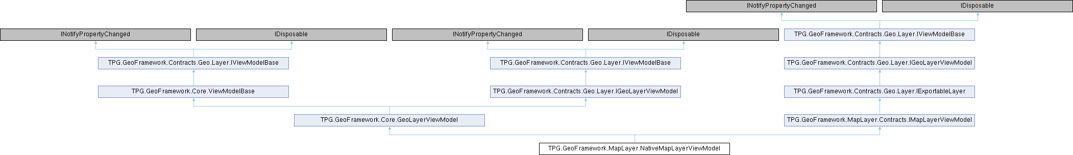
 Public Member Functions inherited from TPG.GeoFramework.Core.GeoLayerViewModel